Mount Chōkai
| Mt. Chōkai | |
|---|---|
| 鳥海山 | |
 | |
| Physical characteristics | |
| Summit Height | 2,236 m |
| Municipalities | Nikaho, Yurihonjō |
| Location in Akita | |
 |
|
Mount Chōkai (鳥海山; -san) is an active volcano located on the southern border of Akita and Yamagata. Mt. Chōkai is the namesake for the Chōkai district in present-day Yurihonjō. Because of its (roughly) symmetrical shape and massive size, it is also known as Dewa no Fuji (出羽の富士) or by Akita natives as Akita Fuji.
Outline

Chōkai is 2,236 meters (7,336 Feet) above sea level, and is shared by Sakata in Yamagata, and Yurihonjō and Nikaho in Akita. While the mountain is shared by the two prefectures, the peak rests on the Yamagatan side of the border. In addition to being one of the 100 landscapes of Japan, it is also included as one of the 100 mountains of Japan, and 100 geographical features of Japan.
Chōkai is the second tallest mountain in Tohoku after Mt. Hiuchigatake in Fukushima. Although Hiuchigatake in the south is technically the taller mountain, it lies on the border of Kanto Region in Gunma, and as such, Chōkai is thought by many to be the tallest true Tohoku mountain.
Chōkai also has certain alpine plant species that can only be found on her slopes. The most common of these is the Chōkai Thistle (チョウカイアザミ). The Chōkai Thistle is a perennial plant, and is currently classified as near threatened by the International Union for Conservation of Nature and Natural Resources.
Near the mountain's peak is a shrine called the Chokaisan-oomono-imi-Jinya (鳥海山大物忌神社). The shrine, which looks like an ordinary cabin with a slanted roof, is located on the Yamagata part of the mountain and is as an annexed shrine of the Association of Shinto Shrines. The kami that is enshrined is Oomono-imi-no-kami (大物忌神), a harvest god of rice which dwells in the mountain that is though to purify and protect all of Tohoku. The kami was first worshiped and ranked in the mid-800s. Tsukiyomi (The shinto god of the moon) is also worshiped at the shrine. It was thought that Chokai's eruptions were caused by the spirit's anger. Two branch shrines for the spirit are located in Fukaura and Warabioka. The shrine grounds were designated a historical landmark in 2008.
Three ships have been named after Mount Chōkai: Japanese gunboat Chōkai, an early steam gunboat and the Chōkai(sunk in 1944), which were both in the Japanese Imperial Navy, and the JDS Chōkai, a Kongō class guided missile destroyer currently in service in the Japan Maritime Self-Defense Force.
Eruptions
- In 466 BC, a massive landslide off of Chōkai deposited large amounts of sediment onto Nikaho, creating the area that is present-day Kisakata.
- Eruptions of various sizes have been recorded in 810, 840, 871, 939, 1560, 1659, 1740, 1800, 1821, 1834, and 1971.
- In 1974, the entire mountain was closed to climbing due to an eruption. The kami at the shrine on the mountain's peak was relocated further down the slope.
Climbing Chōkai
Climbing season officially begins every year on May 1st, however most people choose to wait until mid-late summer to climb Chokai because of the remaining snow on her peak. Until early August, much of the normal path(s) are covered by snow, which make it hard to see the trail markers. Chokai is techincally climbable all year round, although those who choose to climb the mountain while there is still snow should take extra precautions.
Most of the trails up the mountains are very well defined by wear and signs/markings left by previous climbers. All trails eventually lead to a plateau near the top of the mountain where the mountain's shrine, as well as a small hostel and

bathrooms are located. This plateau marks the 99% mark of the mountain, and it is a popular choice for people to start their descent after reaching here. For those who really want to get to the absolute top of the mountain, some extra climbing is required. The final 1% of Chokai consists mostly of huge piles of rocks that rise up into nearly indistinguishable pillars. The two largest are known as the false summit and the true summit, with the path to the true summit being marked by large spray-painted white arrows. The true summit is marked by a small wooden sign that says 鳥海山 2236m.
It is crucial to check the weather of the day you are planning on climbing as rain can turn a fun hike up the mountain into a battle for survival. Much of the Yashima climbing route is based off of a dry river-bed which rapidly turns into an actual river if any appreciable amount of rain falls. Minimum recommended equipment includes: a towel, food, 2-3 bottles (liters) of water, heavy duty shoes, sunscreen, long pants, and a poncho/raincoat. Most routes will take you 3 to 5 hours to get to the top and 2-4 hours to come down, so it is recommended that you start climbing early in the day (7-10am).
Chōkai is not a particularly dangerous mountain if you take the proper precautions. Although there have been deaths, most recently a man from Oga in 2005 from dehydration, they have been from entirely preventable reasons.
Routes
There are 9 bases to climb Chōkai from, although many of the paths later converge midway up the mountain. The two most popular bases to climb from in Akita are explained below.
- Yashima Trail 矢島口 Location on Google Maps
Likely the most challenging of Chokai's standard climbing routes, the Yashima course also boasts the longest history. The Yashima trailhead actually begins at a place called the Haraikawa Campgrounds in Yurihonjo. (祓川キャンプ場). The parking lot at the trailhead is equipped with functioning toilets and running water to fill your bottles. From the Haraikawa parking lot it is 4.4km to the top.
The trail has a gorgeous entrance across fields which later gives way to steep rock steps and large patches of snow that you need to traverse. Some limited vertical climbing is required. Most of the path is along a river which allows climbers a look at a few smaller, but nonetheless beautiful, waterfalls. With breaks it will take an estimated 3 - 4 hours to reach the summit and 2.5-3.5 hours to come back down.
~ 40 minutes by car from Yashima station.

- Kisakata (Hokodate) Trail 象潟口(ほこだて口) Location on Google Maps
The most popular place to start from, it is one of the easier routes, although it takes slightly longer to reach the summit. To get to the trailhead you simply take the route 7 to the 58 and then the 131. There are multiple signs pointing there. The path begins at the Hokodate parking lot which is actually a visitors center where you can stock up on supplies and grab a meal when you come back down.
Compared to the Yashima entrance there are fewer natural obstacles and the path is much better defined. A beautiful natural lake will mark the roughly halfway point (distance wise). After the lake there is a long path which leads to the more challenging section of the hike.
With the exception of a few sketchy ladders, very little actual climbing is required until you reach the summit. Once you reach the summit there is a small camp with places to rest and buy drinks at ridiculous prices. From here you can choose to head back down or attempt the rather challenging scramble up to the actual peak.
With breaks it should take roughly 4-5 hours to reach the summit and 3-4 hours to come down. All told it is best to budget 8-10 hours to complete this hike with a group.
Gallery
-
 Lake on the Kisakata hike
 -
 Another shot on the Kisakata trail
 -
 Chokai in late spring
 -
 Chōkai in winter
 -
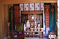 The shrine near the peak


See also
- Hiking/Climbing.
- Life in Akita.
- Site listing all routes. Japanese.
- Wikimedia Commons. Pictures of the mountain.
| Mountains in Akita | |
|---|---|
| North Block | Mt. Moriyoshi • Shirakami Mountains • Mt. Tashiro • Mt. Yakushi |
| Capital Block | Mt. Kanpu • Ogata Fuji • Mt. Taihei |
| South Block | Mt. Akita Komagatake • Mt. Hachimantai • Mt. Kurikoma • Mt. Nyuto |
| Yuri Block | Mt. Chōkai |
| Activities | Hiking/Climbing • Skiing and snowboarding |